Product successfully added to your shopping cart
There are 0 items in your cart. There is 1 item in your cart.
Uitbeelding der heerlijkheit Friesland, zoo in 't algemeen, als in haare... door Dr....
Bernhard Schotanus van Sterringa (*1639 - †1704)Reference 11466
Description
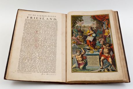
Second and enlarged edition of the first atlas of the Dutch province of Friesland, including 30 detail maps of the entire provinces of Friesland, an overview map of Friesland and 8 historical maps of the Netherlands.
The first edition was produced by Bernard Schotanus in 1698 after he received an order from the Gedeputeerde Staten for a new mapping out of the Grietenijen. This first edition was published in 125 copies only. The rapid topographical changes in Frisia and the small number of printed copies made a new edition necessary just 20 years later. After the death of Schotanus in 1704, François Halma edited and published this 1718 edition in Leeuwarden. He revised the copperplates with information up to date and added the seven historical maps of the Netherlands from Menso Alting, plus a historical overview map of Frisia by Schotanus. The Halma atlas was later re-issued by R & J Ottens. (R. W. Shirley)
Fockema Andreae mentioned in Geschiedenis der Kartografie van Nederland about this atlas:
The execution of these maps is exceptionally beautiful... one of the best and most beautiful documents of our old cartography.
The heraldic plates showing the arms of the province of Friesland, the arms of the fourteen Frisian districts and the arms of William Karel Hendrik Friso, Prince of Orange-Nassau. The splendid allegorical frontispiece, which is also new in this edition, was engraved by Jacob Folkema after a drawing by the artist Gerbrandus van der Haven and especially the poet Johannes Hilarides, who provides a detailed explanation in verse on the back of the title page.
Provenance: Boekhandel W. Eekhoff, Leeuwarden, label on endpaper, 19th century
All maps of this atlas are shown in high resolution on our Atlas-Gallery website: Schotanus/Halma Friesland Atlas
Details
| Cartographer | Bernhard Schotanus van Sterringa |
| Title | Uitbeelding der heerlijkheit Friesland, zoo in 't algemeen, als in haare... door Dr. Bern. Schotanus a Sterringa... Uitgegeeven door Francois Halma, 1718. |
| Publisher, Year | Francois Halma, Leeuwarden, 1718 |
| Size | 57.0 x 37.5 cm (22.4 x 14.8 inches), Imperial Folio |
| Illustrations | 1 engraved copper title, 3 copper engravings, 39 copper engraved maps |
| Cover | Calf binding with blind and gilt stamping |
| Reference | Shirley R. W.: Maps in the Atlases of the British Library: T.HALM-2a; Koeman, vol III, pp. 122-3 |
Condition
Contemporary blind-ruled calf. Richly gold on spine and covers. Corners, edges and spine extremes restored.
All plates brilliantly coloured by a contemporary hand. Complete with all published maps and plates. 19th century blue paper sheet with printed table of contents pasted on endpaper. 19th century blue paper labels with printed map number and title pasted in upper corner on back of each map. Straightened vertical creases around centrefold on half of the maps. Several maps with backed centrefold.
Cartographer
Images to Download
If you like to download the image of this map with a resolution of 1200 pixels, please follow the link below.
You can use this image for publication on your personal or commercial websites for free if you set a link to this website. If you need photographs with a higher resolution, please contact us.
Atlases - Schotanus van Sterringa, Bernhard - Uitbeelding der heerlijkheit Friesland,...


![Ch'onha Chido [Atlas of all under Heaven] Ch'onha Chido [Atlas of all under Heaven]](https://www.vintage-maps.com/3336-home_default/anonymous-korean-manuscript-atlas-chonha-chido-1820.jpg)
![Ch'onha Chido [Atlas of all under Heaven] Ch'onha Chido [Atlas of all under Heaven]](https://www.vintage-maps.com/4291-home_default/anonymous-korean-manuscript-atlas-chonha-chido-1800.jpg)
![Ch'onha chido [Atlas of all under Heaven] Ch'onha chido [Atlas of all under Heaven]](https://www.vintage-maps.com/3314-home_default/anonymous-korean-woodblock-atlas-chonha-chido-1750.jpg)