Product successfully added to your shopping cart
There are 0 items in your cart. There is 1 item in your cart.
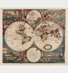
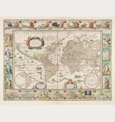
Planiglobii Terrestris cum utroq Hemisphaerio Caelesti Generalis Repraesentatio
Johann Baptist Homann (*1664 - †1724)Reference 12694
Description
Old coloured antique world map by Johann Baptist Homann. With a southern and northern celestial chart and two diagrams about the movement of the sun. In the background windheads and natural phenomena like volcanoes (Etna), earthquakes, tides, geysers in Norway and a rainbow. With the imperial privilege below the title, which was granted to Homann in 1715.
Australia is still incomplete, but already with place names and notes of early discoveries. Both, the east coast of New Zealand with the route of Abel Tasman's first expedition in 1642 and the route of the circumnavigation of the world by Magellan are shown. Remarkable for the early 18th century are the geographical details in Southeast Asia with Japan and the northwest coast of North America.
Details
| Cartographer | Johann Baptist Homann |
| Title | Planiglobii Terrestris cum utroq Hemisphaerio Caelesti Generalis Repraesentatio |
| Publisher, Year | J. B. Homann, Nuremberg, circa 1720 |
| Plate Size | 48.6 x 55.5 cm (19.1 x 21.9 inches) |
| Sheet Size | 54.0 x 62.0 cm (21.3 x 24.4 inches) |
Condition
Cartographer
Images to Download
If you like to download the image of this map with a resolution of 1200 pixels, please follow the link below.
You can use this image for publication on your personal or commercial websites for free if you set a link to this website. If you need photographs with a higher resolution, please contact us.
World Maps - Homann, Johann Baptist - Planiglobii Terrestris cum utroq...


![Ch'onha Chido [Atlas of all under Heaven] Ch'onha Chido [Atlas of all under Heaven]](https://www.vintage-maps.com/3336-home_default/anonymous-korean-manuscript-atlas-chonha-chido-1820.jpg)
![Ch'onha Chido [Atlas of all under Heaven] Ch'onha Chido [Atlas of all under Heaven]](https://www.vintage-maps.com/4291-home_default/anonymous-korean-manuscript-atlas-chonha-chido-1800.jpg)
