Product successfully added to your shopping cart
There are 0 items in your cart. There is 1 item in your cart.
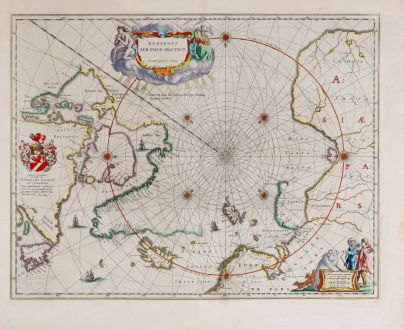
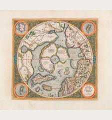
Regiones Sub Polo Arctico
Willem Janszoon Blaeu (*1571 - †1638)Reference 12043
Description
Old coloured sea chart of the North Pole by Willem Blaeu. With Greenland and Canada, Iceland, Spitsbergen, Norway and the north coast of Russia. The map shows, the famous Northwest Passage, a connection between the Atlantic and the Pacific in the north of North America, does not exist.
Philip D. Burden in The Mapping of North America about this map:
The unknown north-west coast is conveniently hidden behind a decorative title cartouche. Two foxes, two hunters and a polar bear grace a second cartouche bearing the imprint. One unusual feature of this map is the attempt to show rhumb lines on a polar map...
Details
| Cartographer | Willem Janszoon Blaeu |
| Title | Regiones Sub Polo Arctico |
| Publisher, Year | Joan Blaeu, Amsterdam, 1643-50 |
| Plate Size | 41.1 x 53.0 cm (16.2 x 20.9 inches) |
| Sheet Size | 51.0 x 59.8 cm (20.1 x 23.5 inches) |
| Reference | Burden, P.D.: The Mapping of North America No. 252 2nd state; Van der Krogt, P.: Koeman's Atlantes Neerlandici, 0020:2.2 |
Condition
Cartographer
Images to Download
If you like to download the image of this map with a resolution of 1200 pixels, please follow the link below.
You can use this image for publication on your personal or commercial websites for free if you set a link to this website. If you need photographs with a higher resolution, please contact us.
North - South Pole - Blaeu, Willem Janszoon - Regiones Sub Polo Arctico

