Product successfully added to your shopping cart
There are 0 items in your cart. There is 1 item in your cart.
Total products

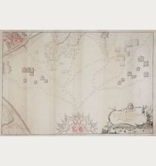
Plan Van Een Halve 6 Hoek na de Constructie Van de marchal de Vauban met een Wilkeurige...
AnonymousManuscript plan of a study on military cartography. Drawn in 1776.
Reference 12077
Description
Carefully executed cartographic study, based on the methods of the French military corps Ingénieurs-Géographes, established by Vauban in 1696. With a charming title cartouche Plan Van Een Halve 6 Hoek Van Vauban de Constructie met een Wilkeurige Situatie getekend in't Matimatisch Militaire College te S'Bosch den 7e Meij 1776.... Drawn with black and red ink on paper, wash colours in red.
Details
| Cartographer | Anonymous |
| Title | Plan Van Een Halve 6 Hoek na de Constructie Van de marchal de Vauban met een Wilkeurige Situatie... |
| Publisher, Year | 1776 |
| Plate Size | 34.2 x 50.5 cm (13.5 x 19.9 inches) |
| Sheet Size | 38.0 x 54.3 cm (15.0 x 21.4 inches) |
Condition
Some small tears in margins.
Images to Download
If you like to download the image of this map with a resolution of 1200 pixels, please follow the link below.
You can use this image for publication on your personal or commercial websites for free if you set a link to this website. If you need photographs with a higher resolution, please contact us.
Anonymous: Plan Van Een Halve 6 Hoek na de Constructie Van de marchal de Vauban met een Wilkeurige Situatie....
Manuscript plan of a study on military cartography. Drawn in 1776.

![[Manuscript Chart of the South Atlantic Ocean] Tweede stuck wassende Graedkaert van de Kaap Verdische Eilanden tot de Kaap [Manuscript Chart of the South Atlantic Ocean] Tweede stuck wassende Graedkaert van de Kaap Verdische Eilanden tot de Kaap](https://www.vintage-maps.com/3745-home_default/blaeu-manuscript-1690.jpg)
![Ch'onha Chido [Atlas of all under Heaven] Ch'onha Chido [Atlas of all under Heaven]](https://www.vintage-maps.com/3336-home_default/anonymous-korean-manuscript-atlas-chonha-chido-1820.jpg)
![[Donau Strom von Sigmaringen bis Donauwörth] [Donau Strom von Sigmaringen bis Donauwörth]](https://www.vintage-maps.com/2606-home_default/anonymous-germany-baden-wuerttemberg-danube-1702.jpg)
![Ch'onha Chido [Atlas of all under Heaven] Ch'onha Chido [Atlas of all under Heaven]](https://www.vintage-maps.com/4291-home_default/anonymous-korean-manuscript-atlas-chonha-chido-1800.jpg)
![[Aa-Berlicum-Erp] [Aa-Berlicum-Erp]](https://www.vintage-maps.com/2588-home_default/anonymous-netherlands-river-aa-1780.jpg)
![Ch'onha chido [Atlas of all under Heaven] Ch'onha chido [Atlas of all under Heaven]](https://www.vintage-maps.com/3314-home_default/anonymous-korean-woodblock-atlas-chonha-chido-1750.jpg)
