Product successfully added to your shopping cart
There are 0 items in your cart. There is 1 item in your cart.
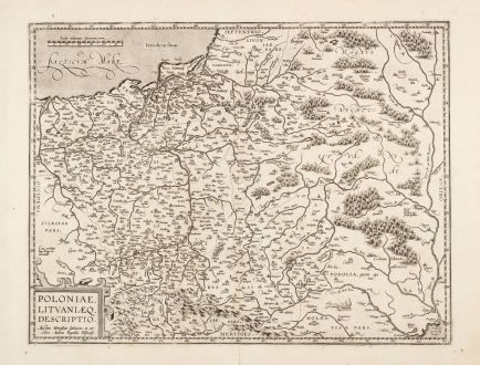
Poloniae, Lituaniaeq. Descriptio.
Abraham Ortelius (*1527 - †1598)Reference 12935
Description
Beautiful antique map of Poland by Abraham Ortelius. From the first modern atlas, the famous Theatrum Orbis Terrarum by Ortelius, first published in 1570. Embellished with elaborate details and decorative elements.
This is the second map of Poland by Ortelius featured in the Theatrum Orbis Terrarum. Similar to the first map, it relies on a cartographic work by Vacovas Godreckis, although the sole surviving example of Godreckis' map was unfortunately lost in 1945. Notably, this version incorporates corrections made by the Polish physician Andrzej Pograbski, particularly in the eastern section of the map. The map first appeared in the Theatrum in 1595. Decorated with a sailing ship and a cartouche. From the 1601 Latin edition of Theatrum Orbis Terrarum, Latin text on verso.
Details
| Cartographer | Abraham Ortelius |
| Title | Poloniae, Lituaniaeq. Descriptio. |
| Publisher, Year | Antwerp, 1601 |
| Plate Size | 37.0 x 48.5 cm (14.6 x 19.1 inches) |
| Sheet Size | 44.4 x 57.3 cm (17.5 x 22.6 inches) |
| Reference | Van den Broecke, M.: Ortelius Atlas Maps, No. 155/1601L98 |
Condition
Cartographer
Images to Download
If you like to download the image of this map with a resolution of 1200 pixels, please follow the link below.
You can use this image for publication on your personal or commercial websites for free if you set a link to this website. If you need photographs with a higher resolution, please contact us.
Poland - Ortelius, Abraham - Poloniae, Lituaniaeq. Descriptio.

