Product successfully added to your shopping cart
There are 0 items in your cart. There is 1 item in your cart.
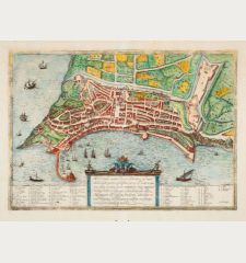
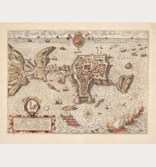
Palermo citta principalissima della Sicilia...
Natal Bonifacio (*1537 - †1592)Reference 12831
Description
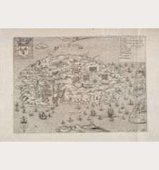
Important and First Large Printed Map of the City of Palermo by Natale Bonifacio.
A very fine and rare map of Palermo by Natale Bonifacio. The detailed plan of Palermo and its surrounding lands showing the Royal Palace, the fortress and harbors, the fortifications, the street plan, and houses. This is the second state (of two) of the Palermo map, which was designed by Orazio Maiocchi (Maiocco) and engraved by Natale Bonifacio. It was published by Claudio Duchetti and bears the address of Giovanni Orlandi.
The map prominently features the imperial coat of arms of the royal house of Austria-Spain at its center. In the cartouches located at the top left and right, crowned with the Colonna-Orsini coat of arms, you'll find the dedication.
Along the bottom margin, there's a numerical key consisting of 128 references to notable places and monuments, arranged in 15 columns. The last cartouche provides editorial details: Presbiter Horatius Maiocchus Inventor. Natalis Bonifatius Fecit. Ioannes Orlandi fomis romae 1602. Romae Apud Claudij Duchetij Anno D[omi]n[i]. 1580.
Among the most popular cartographic works are the Italian atlases of the 16th century, the so-called Lafreri atlases, an individual composition of maps of different types and sizes. The maps are very rare and can often only be found in large libraries and state collections.
Rarity
This work is exceptionally rare, with only 12 known examples preserved in public collections worldwide (refer to Bifolco-Ronca, 2018, #1178).
Details
| Cartographer | Natal Bonifacio |
| Title | Palermo citta principalissima della Sicilia... |
| Publisher, Year | Giovanni Orlandi, Rome, 1580 [1602] |
| Plate Size | 53.0 x 40.4 cm (20.9 x 15.9 inches) |
| Sheet Size | 54.5 x 51.5 cm (21.5 x 20.3 inches) |
| Reference | Bifolco S. & Ronca F.: Cartografia e topografia italiana del XVI secolo, No. 1178 II/II; Tooley, R.V.: Maps in Italian Atlases of the Sixteenth Century, No. 431/432. |
Condition
Cartographer
Images to Download
If you like to download the image of this map with a resolution of 1200 pixels, please follow the link below.
You can use this image for publication on your personal or commercial websites for free if you set a link to this website. If you need photographs with a higher resolution, please contact us.
Italy - Bonifacio, Natal - Palermo citta principalissima della...

![Natal Bonifacio: Palermo citta principalissima della Sicilia... Antique Maps, Bonifacio, Italy, Sicilia, Sicily, Palermo, 1580 [1602]: Palermo citta principalissima della Sicilia...](https://www.vintage-maps.com/4283-large_default/bonifacio-italy-sicilia-sicily-palermo-1580-1602.jpg)


![[Sardigna, Sardinia, Sardegna] [Sardigna, Sardinia, Sardegna]](https://www.vintage-maps.com/2947-home_default/bordone-italy-sardinia-sardegna-1528-1565.jpg)
