Product successfully added to your shopping cart
There are 0 items in your cart. There is 1 item in your cart.
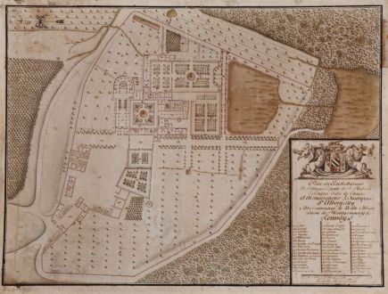
Plan du Rezdechaussee De l'Abbayé Royale de S. Andre En Gouffern Ordre de Citaux a...
AnonymousReference 11525
Description
Plan manuscrit de l'Abbaye de Saint-André-en-Gouffern à La Hoguette, Calvados.
Important manuscript map of the Abbey Saint-André-en-Gouffern in La Hoguette, Calvados.
Large, impressive and highly detailed manuscript plan of the Cistercian Monastery Saint-André-de-Gouffern, La Hoguette close to Falaise in the Calvados, Normandy. The drawing is executed very skilfully. All trees in the garden, the forests and all objects have shades and appear three-dimensional. The garden shows several fountain, even at some walls individual stones are visible.
The plan was created during the first half of the 18th century, while Marquis d'Albergotti headed the Abbey. Top left a skilful arrow shows the direction to the north. To the lower right a beautiful title cartouche with coat of arms, horses, Putti and a key specifies the buildings and places. Black ink on paper, coloured in red, blue and two green tones. Old mounted on linen.
Details
| Cartographer | Anonymous |
| Title | Plan du Rezdechaussee De l'Abbayé Royale de S. Andre En Gouffern Ordre de Citaux a Monseigneur le Marquis d'Albergotti. Abbe Commendeur de la dite Abbaye Baron de Montgommery & Renvoy |
| Publisher, Year | circa 1730 |
| Plate Size | 55.0 x 74.0 cm (21.7 x 29.1 inches) |
| Sheet Size | 58.0 x 76.5 cm (22.8 x 30.1 inches) |
Condition
Images to Download
If you like to download the image of this map with a resolution of 1200 pixels, please follow the link below.
You can use this image for publication on your personal or commercial websites for free if you set a link to this website. If you need photographs with a higher resolution, please contact us.
France - Anonymous - Plan du Rezdechaussee De l'Abbayé Royale...




![Ch'onha chido [Atlas of all under Heaven] Ch'onha chido [Atlas of all under Heaven]](https://www.vintage-maps.com/3314-home_default/anonymous-korean-woodblock-atlas-chonha-chido-1750.jpg)
![Ch'onha Chido [Atlas of all under Heaven] Ch'onha Chido [Atlas of all under Heaven]](https://www.vintage-maps.com/3336-home_default/anonymous-korean-manuscript-atlas-chonha-chido-1820.jpg)
![Ch'onha Chido [Atlas of all under Heaven] Ch'onha Chido [Atlas of all under Heaven]](https://www.vintage-maps.com/4291-home_default/anonymous-korean-manuscript-atlas-chonha-chido-1800.jpg)
