Product successfully added to your shopping cart
There are 0 items in your cart. There is 1 item in your cart.
Total products
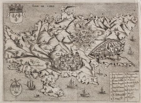
Isle de Cipre
Henry RaigniauldAntique map of Cyprus. Printed in Paris by J. Baudoin oder A. de Naberat in 1629 or 1640.
Reference 12133
Description
Rare map of Cyprus engraved by H. Raigniauld. The map comes from Histoire des Chevaliers de l'Ordre de S. Iean de Hierusalem by J. Baudoin printed 1629 in Paris, or from the 1640 edition by A. de Naberat. With two coats of arms, several sailing ships and a key of 1-16 to the lower right.
Details
| Cartographer | Henry Raigniauld |
| Title | Isle de Cipre |
| Publisher, Year | J. Baudoin oder A. de Naberat, Paris, 1629 or 1640 |
| Plate Size | 19.0 x 26.5 cm (7.5 x 10.4 inches) |
| Sheet Size | 20.7 x 28.0 cm (8.1 x 11.0 inches) |
| Reference | Stylianou, A. & J.: The History of the Cartography of Cyprus, No. 110; Zacharakis, C. G.: A Catalogue of printed Maps of Greece, 3rd edition, #2878/1878 |
Condition
Slight vertical folds right of the centrefold. Very good condition.
Cartographer
Henry Raigniauld, also known as Raignauld, was a French engraver during the early 1600s.
Images to Download
If you like to download the image of this map with a resolution of 1200 pixels, please follow the link below.
You can use this image for publication on your personal or commercial websites for free if you set a link to this website. If you need photographs with a higher resolution, please contact us.
Henry Raigniauld: Isle de Cipre.
Antique map of Cyprus. Printed in Paris by J. Baudoin oder A. de Naberat in 1629 or 1640.



![[Die Tafel gibt ein klein anzeigung...] [Die Tafel gibt ein klein anzeigung...]](https://www.vintage-maps.com/1544-home_default/muenster-holy-land-israel-cyprus-1574.jpg)

