Product successfully added to your shopping cart
There are 0 items in your cart. There is 1 item in your cart.

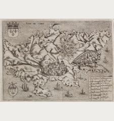
Cipro - Descrittione dell'Isola di Cipro.
Tomaso Porcacchi (*1530 - †1585)Reference 12369
Description
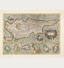
First edition of Porcacchi's very attractive and early map of Cyprus. One of the earliest obtainable separate maps of Cyprus. This finely-executed map shows the Mediterranean island of Cyprus. With a compass rose, a decorative title cartouche and several sea monsters. Very skillfully engraved by Girolamo Porro.
Andreas and Judith A. Stylianou in The History of the Cartography of Cyprus about this map:
The finely engraved little map is a work of art. Its name Cipro is framed by a decorative small cartouche. Its geographical features are based on the loose-sheet copperplate map issued by Giovanni Francesco Camocio ... itself based on that of Matheo Pagano, Venice 1538.
From the rare first edition of the famous L'Isole piu famose del Mondo the Isolario or Book of Islands by the Italian humanist and scholar Tomaso Porcacchi. Published 1572 in Venezia in a collaboration with the bookseller Simone Galignani and the Paduan engraver Girolamo Porro. A second edition followed in 1576, and further editions posthumously in 1590, 1604, 1605, 1620, 1686 and 1713.
Details
| Cartographer | Tomaso Porcacchi |
| Title | Cipro - Descrittione dell'Isola di Cipro. |
| Publisher, Year | Simon Galignani, Girolamo Porro, Venice, 1572 |
| Plate Size | 10.5 x 14.2 cm (4.1 x 5.6 inches) |
| Sheet Size | 29.5 x 20.0 cm (11.6 x 7.9 inches) |
| Reference | Stylianou, A. & J.: The History of the Cartography of Cyprus, No. 75 (fig. 78); Zacharakis, C.G.: A Catalogue of Printed Maps of Greece, 1477-1800, No. 2743/1795 |
Condition
Cartographer
Images to Download
If you like to download the image of this map with a resolution of 1200 pixels, please follow the link below.
You can use this image for publication on your personal or commercial websites for free if you set a link to this website. If you need photographs with a higher resolution, please contact us.
Cyprus - Porcacchi, Tomaso - Cipro - Descrittione dell'Isola di Cipro.



![[Die Tafel gibt ein klein anzeigung...] [Die Tafel gibt ein klein anzeigung...]](https://www.vintage-maps.com/1544-home_default/muenster-holy-land-israel-cyprus-1574.jpg)

