Product successfully added to your shopping cart
There are 0 items in your cart. There is 1 item in your cart.
Total products
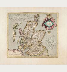
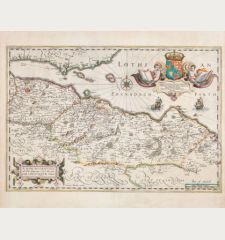
Scotiae Regnum [2 Maps, North and South Scotland]
Gerard Mercator (*1512 - †1594)Coloured map of Scotland, British Isles. Printed in Amsterdam by Henricus Hondius in 1633.
Reference 12830
Description
Large, two-sheet map of Scotland by G. Mercator. Consists of two double-page engraved maps that, when combined, form a large and comprehensive map of Scotland. The two sheets are not joined together. Size is given for one sheet.
Decorated with a large title cartouche at upper left. From the French edition of the Atlas Novus, printed in 1633.
Details
| Cartographer | Gerard Mercator |
| Title | Scotiae Regnum [2 Maps, North and South Scotland] |
| Publisher, Year | Henricus Hondius, Amsterdam, 1633 |
| Plate Size | 35.0 x 45.4 cm (13.8 x 17.9 inches) |
| Sheet Size | 48.0 x 57.0 cm (18.9 x 22.4 inches) |
| Reference | Van der Krogt, P.: Koeman's Atlantes Neerlandici, 5801:1.1 + 5802:1.1 |
Condition
Very good condition.
Cartographer
Gerard Mercator (Kremer) was born in Rupelmonde in Flanders and studied in Louvain. He drawn his first map in 1537 and became a cartographer and globe maker. In 1552 he moved to Duisburg, Germany where he published his famous 18-sheet world map in 1569 with his own new projection, today called Mercator projection. Later he decided to publish a new edition of Ptolemy's Geographia. Followed by his major work, a 3 volume collection of maps to which the word Atlas was applied the first time. The first volume was published 1585, followed by the second in 1589 and the third one after his death in 1595 by his son Rumold. A second edition of all three parts was published 1602. 1604 Jodocus Hondius acquired the plates and published several edition together with his sons Jodocus II and Henricus until 1633. More editions followed until 1666 by Janssonius who was in partnership with Henricus. Some of the plated where also used by W.J. Blaeu in 1630.
Images to Download
If you like to download the image of this map with a resolution of 1200 pixels, please follow the link below.
You can use this image for publication on your personal or commercial websites for free if you set a link to this website. If you need photographs with a higher resolution, please contact us.
Gerard Mercator: Scotiae Regnum [2 Maps, North and South Scotland].
Coloured map of Scotland, British Isles. Printed in Amsterdam by Henricus Hondius in 1633.
Scotland - Mercator, Gerard - Scotiae Regnum [2 Maps, North and South...

![Gerard Mercator: Scotiae Regnum [2 Maps, North and South Scotland] Antique Maps, Mercator, British Isles, Scotland, 1633: Scotiae Regnum [2 Maps, North and South Scotland]](https://www.vintage-maps.com/4278-large_default/mercator-british-isles-scotland-1633.jpg)

![[British Isles and England & Wales] [British Isles and England & Wales]](https://www.vintage-maps.com/2941-home_default/bordone-british-isles-england-and-wales-1528-1565.jpg)
![[The Firth of Murry] - To the Rt Hon.ble, my Lord Viscount Torbat, Lord Register of the Kingdom of Scotland [The Firth of Murry] - To the Rt Hon.ble, my Lord Viscount Torbat, Lord Register of the Kingdom of Scotland](https://www.vintage-maps.com/2244-home_default/collins-scotland-north-sea-moray-firth-inverness.jpg)
