Product successfully added to your shopping cart
There are 0 items in your cart. There is 1 item in your cart.
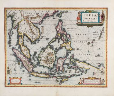
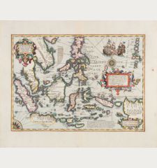
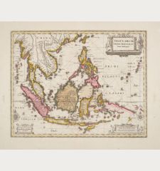
Indiae Orientalis Nova Descriptio
Johannes Janssonius (*1588 - †1664)Reference 12773
Description
One of the Earliest Editions of Janssonius' Important Map of Southeast Asia.
Johannes Janssonius' 1630 map is a significant early depiction of Southeast Asia, the Philippines, and Australia. Notably, it stands out as the sole Dutch printed map showcasing the 1606 expeditions of Willem Jansz, who, aboard the Duyfken, is credited with the first recorded European discovery in Australia - specifically on Cape York Peninsula.
During this time, the Dutch East India Company (V.O.C.) sought to expand its trade monopoly in the East Indies by exploring and claiming additional territories in the region. In 1605, Jan Verschoor, responsible for trade affairs, encouraged a voyage to uncover "New Guinea" and other unknown eastern and southern lands. Willem Jansz was chosen for the expedition and embarked on the Duyfken from Bantam (Indonesia) in late 1605. John Saris, an agent for the British East India Company, documented that the Duyfken departed from Bantam on November 28, 1605 (Schilder p.44).
In early 1606, Jansz sailed down the south coast of New Guinea and continued south across Torres Strait, mistaking it for a shallow bay. He proceeded further south, presuming he was following the New Guinea coast, but in reality, he was navigating waters along the Australian coast. Unbeknownst to him, Jansz became the first European to set foot on Australian soil, specifically the western coast of Cape York Peninsula.
Janssonius' map holds significance as one of the earliest depictions of the Duyfken's discoveries in New Guinea ("Duyfkens Eylant") and marks the first printed record of these findings. Prior to Gerritsz's 1622 map and the unearthing of a copy of the Duyfken's original chart, Janssonius' map stood as the sole cartographic evidence of part of the Duyfken's route in southern New Guinea in 1606, as well as Dutch exploration in the Cape region at large.
However, Janssonius' map does not provide detailed information on Jansz's discoveries in Australia. Instead, the mapmaker employs a scale of miles to cover the area where these discoveries would have been charted. While it was conventionally believed that Janssonius' map was initially published in 1633, Peter van der Krogt notes that it actually first appeared in Janssonius' Appendix in 1630.
Details
| Cartographer | Johannes Janssonius |
| Title | Indiae Orientalis Nova Descriptio |
| Publisher, Year | Henricus Hondius, Amsterdam, 1633 |
| Plate Size | 39.0 x 50.4 cm (15.4 x 19.8 inches) |
| Sheet Size | 47.7 x 56.7 cm (18.8 x 22.3 inches) |
| Reference | Van der Krogt, P.: Koeman's Atlantes Neerlandici, 8500:1B.1; Schilder, G.: Australia Unveiled, The share of the Dutch navigators in the discovery of Australia, No. 24 |
Condition
Cartographer
Images to Download
If you like to download the image of this map with a resolution of 1200 pixels, please follow the link below.
You can use this image for publication on your personal or commercial websites for free if you set a link to this website. If you need photographs with a higher resolution, please contact us.
Southeast Asia - Janssonius, Johannes - Indiae Orientalis Nova Descriptio

![[Maidegascar, Zanzibar, Scorsia, Inebila, Imangla, Scilam, Dondina] [Maidegascar, Zanzibar, Scorsia, Inebila, Imangla, Scilam, Dondina]](https://www.vintage-maps.com/2957-home_default/bordone-east-africa-madagascar-sri-lanka-1528-1565.jpg)
![[Java Minore] [Java Minore]](https://www.vintage-maps.com/2959-home_default/bordone-southeast-asia-indonesia-sumatra-thailand-borneo.jpg)
