Product successfully added to your shopping cart
There are 0 items in your cart. There is 1 item in your cart.
Total products
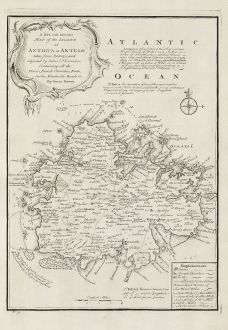
A New and Accurate Map of the Island of Antigua or Antego ... Containing All the Towns,...
Emanuel Bowen (*1693 - †1767)Antique map of Antigua, West Indies. Printed in London by E. Bowen in 1747.
Reference 11048
Description
Bowen's maps of Antigua from 'A Complete System of Geography'. Decorated with a compass rose and a title cartouche. With extensive details and annotations.
Details
| Cartographer | Emanuel Bowen |
| Title | A New and Accurate Map of the Island of Antigua or Antego ... Containing All the Towns, Parish Churches, Forts, Castles, Windmills, Roads &c. |
| Publisher, Year | E. Bowen, London, 1747 |
| Plate Size | 32.2 x 23.2 cm (12.7 x 9.1 inches) |
| Sheet Size | 42.7 x 25.8 cm (16.8 x 10.2 inches) |
Condition
Excellent conditions.
Cartographer
Emanuel Bowen was a printer, publisher and map engraver in London during the mid-eighteenth century. From 1714 onwards he worked in London and began to produce some of the finest and most attractive maps of the century.
Images to Download
If you like to download the image of this map with a resolution of 1200 pixels, please follow the link below.
You can use this image for publication on your personal or commercial websites for free if you set a link to this website. If you need photographs with a higher resolution, please contact us.
Emanuel Bowen: A New and Accurate Map of the Island of Antigua or Antego ... Containing All the Towns, Parish Churches, Forts, Castles,....
Antique map of Antigua, West Indies. Printed in London by E. Bowen in 1747.
Central America - Caribbean - Bowen, Emanuel - A New and Accurate Map of the Island of...

![[West Indies, Jamaica, Hispaniola and South America] [West Indies, Jamaica, Hispaniola and South America]](https://www.vintage-maps.com/3035-home_default/bordone-central-america-caribbean-jamaica-hispaniola.jpg)
![[Lesser Antilles, West Indies] Guadalupe, Dominica, Matinina [Lesser Antilles, West Indies] Guadalupe, Dominica, Matinina](https://www.vintage-maps.com/3027-home_default/bordone-central-america-caribbean-guadeloupe-martinique.jpg)
