Product successfully added to your shopping cart
There are 0 items in your cart. There is 1 item in your cart.
Total products
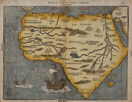
Africa Tertia pars Terrae
Heinrich Bünting (*1545 - †1606)Coloured woodcut map of Africa. Printed in Magdeburg in the year 1581.
Reference 11197
Description
Rare and early woodcut map of Africa by Heinrich Bunting. The map has an unusual shape, tapering to a narrow angle in the south. Several rivers appear in West Africa and as tributaries to the Nile. Mountain chains and various kingdoms are mentioned. The sea is engraved in narrow wavy lines, with a galleon, a merman and above him a sea-bird. Bunting's work Itinerarium Sacrae Scriptura was essentially a theological commentary with other maps of great curiosity. German text on verso.
Details
| Cartographer | Heinrich Bünting |
| Title | Africa Tertia pars Terrae |
| Publisher, Year | Magdeburg, 1581 |
| Plate Size | 26.5 x 35.5 cm (10.4 x 14.0 inches) |
| Sheet Size | 28.4 x 36.8 cm (11.2 x 14.5 inches) |
Condition
Tears to bottom and upper centrefold backed. Traces of vertical folding flatted. Strong and clear impression.
Cartographer
Heinrich Bünting was a protestant Theologian and Chronicler. His main work Itinerarium sacrae scripturae first published 1581, was much valued, mainly because of its emblematic maps, which show the world arranged in the form of a clover leaf with Jerusalem at the centre, Europe in the form of a Queen and Asia in the form of Pegasus.
Images to Download
If you like to download the image of this map with a resolution of 1200 pixels, please follow the link below.
You can use this image for publication on your personal or commercial websites for free if you set a link to this website. If you need photographs with a higher resolution, please contact us.
Heinrich Bünting: Africa Tertia pars Terrae.
Coloured woodcut map of Africa. Printed in Magdeburg in the year 1581.

![[Tab. Mo. Primae Partis Aphricae et Tabula Secunde partis Aphricae.] [Tab. Mo. Primae Partis Aphricae et Tabula Secunde partis Aphricae.]](https://www.vintage-maps.com/3651-home_default/fries-north-africa-1525.jpg)
![[Nile River delta] [Nile River delta]](https://www.vintage-maps.com/2049-home_default/muenster-egypt-nile-river-1574.jpg)
