Product successfully added to your shopping cart
There are 0 items in your cart. There is 1 item in your cart.
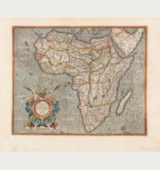
Africa Lybia Morenlandt mit allen königreichen so zu unsern zeiten darin gefunden werden.
Sebastian Münster (*1489 - †1552)Reference 12839
Description
A very fine example of the earliest obtainable printed map to show all of Africa. First published in 1540 by Sebastian Munster, this map is also famous because of its rich mythical content. The Monoculi or cyclops around Nigeria, an elephant in South Africa, crowns and sceptres indicate kingdoms all over the continent. Decorated with a large galleon under full sail westward of South Africa. Title on verso surrounded by a beautiful woodcut border.
From the German edition of Sebastian Munster's Cosmography, titled Cosmographey oder beschreibung aller Länder, published 1578 by Heinrich Petri in Basel. The woodblock of this map was first used in Seb. Munster's Geographia Universalis in 1540.
Details
| Cartographer | Sebastian Münster |
| Title | Africa Lybia Morenlandt mit allen königreichen so zu unsern zeiten darin gefunden werden. |
| Publisher, Year | Heinrich Petri, Basle, 1540 [1578] |
| Plate Size | 25.7 x 34.3 cm (10.1 x 13.5 inches) |
| Sheet Size | 33.0 x 38.6 cm (13.0 x 15.2 inches) |
| Reference | Norwich, O.I.: Maps of Africa, No. 2; Tooley, R.V.: Collector's Guide to Maps of the African Continent and South Africa, No. 9. |
Condition
Cartographer
Images to Download
If you like to download the image of this map with a resolution of 1200 pixels, please follow the link below.
You can use this image for publication on your personal or commercial websites for free if you set a link to this website. If you need photographs with a higher resolution, please contact us.
Africa Continent - Münster, Sebastian - Africa Lybia Morenlandt mit allen...

![Sebastian Münster: Africa Lybia Morenlandt mit allen königreichen so zu unsern zeiten darin gefunden werden. Antique Maps, Münster, Africa Continent, 1540 [1578]: Africa Lybia Morenlandt mit allen königreichen so zu unsern zeiten darin gefunden werden.](https://www.vintage-maps.com/4311-large_default/muenster-africa-continent-1540-1578.jpg)
![Aldenburg [Aldenbvrg] Aldenburg [Aldenbvrg]](https://www.vintage-maps.com/2177-home_default/muenster-germany-lower-saxony-stade-1574.jpg)
