Produkt wurde in den Korb gelegt
Sie haben 0 Artikel in Ihrem Warenkorb. Es gibt 1 Artikel in Ihrem Warenkorb.
Gesamt Artikel
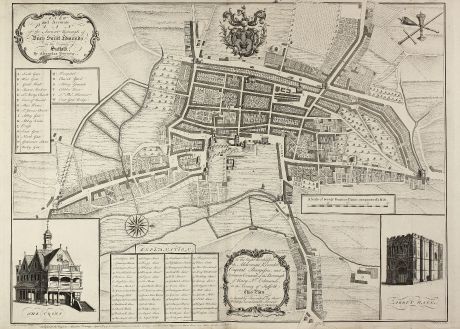
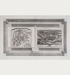
A New and Accurate Plan of the Ancient Borough of Bury Saint Edmunds in the Country of...
Alexander DowningAntike Landkarte von Bury St. Edmunds, Suffolk. Gedruckt bei A. Downing im Jahre 1741 in London.
Artikel-Nr. 10981
Beschreibung
Großer, seltener Stadtplan von Bury St. Edmunds
A large and detailed copper engraved plan of Bury St. Edmunds, Suffolk, drawn and published by Alexander Downing in 1741, engraved by W.H. Toms, engraver in Union Court, and sold by Samuel Matson, Bookseller at Bury. Oriented with north to the right of the page, the plan is dedicated by Downing to 'To the Right Worshipful the Alderman, Recorder, Capital Burgesses, and Common Council of the Borough of Bury St. Edmunds, in the County of Suffolk. This plan is humbly Inscribed by their Worships most humble Servant Alex: Downing'.
A title cartouche appears in the upper left corner, two large vignette illustrations of 'The Cross' and 'Abbey Gate' in the lower corners, a compass rose, coat of arms, a mileage scale and a key from 1 to 55 with street names, another key from A to W with important buildings. At the bottom of the plate the participating persons are mentioned: 'Published by the Proprietor Alexander Downing, April 24th, 1741. & sold by Sam. Watson, Bookseller at Bury, and W.H. Toms, Engraver in Union Court near Hatton Garden, Holborn.'
This is first state of the map, published by A. Downing itself. There was a second state published by J. Rocque in 1761. We only could locate one copy of this first state in the Library of Yale, non in COPAC (British Libraries).
Details
| Kartograph | Alexander Downing |
| Titel | A New and Accurate Plan of the Ancient Borough of Bury Saint Edmunds in the Country of Suffolk By Alexander Downing. 1740. |
| Verlag, Jahr | A. Downing, London, 1741 |
| Bildgröße | 51.4 x 69.0 cm |
| Blattgröße | 53.0 x 74.2 cm |
Erhaltung
Spuren von zwei vertikalen und einer horizontalen Falte, ein kleiner Einriß in der Bugfalte hinterlegt. Sehr gute Erhaltung.
Bilder zum Herunterladen
Falls Sie die Bilder dieser Karte in einer Auflösung von 1200 Pixeln herunterladen möchten, folgen Sie bitte unten stehendem Verweis.
Sie können die Bilder auf Ihrer privaten oder kommerziellen Internetseite frei veröffentlichen, sofern Sie einen Verweis (Link) auf diese Webseite setzen. Falls Sie Fotos in höherer Auflösung benötigen, kontaktieren Sie uns bitte.
Alexander Downing: A New and Accurate Plan of the Ancient Borough of Bury Saint Edmunds in the Country of Suffolk By Alexander Downing. 1740..
Antike Landkarte von Bury St. Edmunds, Suffolk. Gedruckt bei A. Downing im Jahre 1741 in London.
Britische Inseln - Downing, Alexander - A New and Accurate Plan of the Ancient...

![[British Isles and England & Wales] [British Isles and England & Wales]](https://www.vintage-maps.com/2941-home_default/bordone-britische-inseln-england-und-wales-1528-1565.jpg)

![[The Firth of Murry] - To the Rt Hon.ble, my Lord Viscount Torbat, Lord Register of the Kingdom of Scotland [The Firth of Murry] - To the Rt Hon.ble, my Lord Viscount Torbat, Lord Register of the Kingdom of Scotland](https://www.vintage-maps.com/2244-home_default/collins-britische-inseln-schottland-nordsee-moray-firth-inverness.jpg)
